| Ocean Water Related - Press Release
Ocean Water Quality Rain Advisory:
Advisory for all Los Angeles County Beaches
in Effect Until Saturday, October 18, 2025, at 5:00am 10/14/2025
Ocean Water Use Warning for Los Angeles County Beaches 10/10/2025 The Los Angeles County Department of Public Health cautions residents who are planning to visit the below Los Angeles County beaches to avoid swimming, surfing, and playing in ocean waters: BEACH AREA WARNINGS: · Manhattan Beach Pier in Manhattan Beach 100 yards up and down the coast from the pier. · White Point at Royal Palms Be....
Click here for the complete release.
|
| Ocean Water Quality Rain Advisory A rain advisory is issued when there is significant rainfall that may cause bacteria levels in ocean waters to increase. Bacteria levels can increase significantly during and after rainstorms, as contaminants within the runoff enters the ocean. Bacteria levels may remain elevated up to 3 days depending upon the intensity of the rain and the volume of runoff. Elevated bacteria levels in ocean water may cause illness, especially in children and the elderly. The Department of Public Health recommends that beach users avoid contact with ocean water for a period of 3 days after significant rainfall, especially near flowing storm drains, creeks and rivers. An Ocean Water Quality Rain Advisory has been declared for all Los Angeles County beaches. The advisory will be in effect at least until 5:00 am, Saturday October 18, 2025. Beach users are cautioned to avoid water contact for at least 72 hours after rainfall. This advisory may be extended depending upon further rainfall. |
|
Beach Water Quality
Testing
This map is updated as conditions change. |
|
Water Quality Sampling
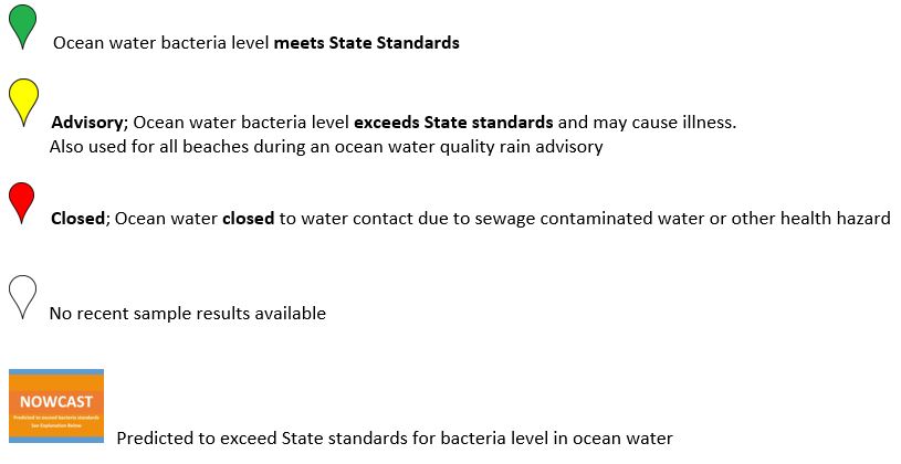
Laboratory results from three local agencies are displayed on the map. The Los Angeles County Department of Public Health (DPH) Environmental Health Recreational Waters Program, collects ocean water samples from the mainland, once a week throughout the year. DPH collects an additional five samples from Avalon on Santa Catalina Island beginning in April through October. The Los Angeles County Sanitation Districts (SD) collects ocean water samples at selected sites on the mainland, once each week throughout the year. The Beach Cities of Redondo Beach, Manhattan Beach and Hermosa Beach, Palos Verdes Estates and Rancho Palos Verdes (BC) jointly collect water samples within their cities, once a week throughout the year. DPH, SD, and BC also resample sites that have exceeded State Standards for bacteria in ocean water. The City of Los Angeles, Environmental Monitoring Division, LA Sanitation (HYP) collects water samples from various sites, one to five times per week, all year round. LA City also collects samples at some DPH sites as required by their State NPDES permit. The public is notified when a site has exceeded State Standards for bacteria in ocean water on this website, by telephone hotline, and by signs posted at the impacted beaches.
Beach Closures
Ocean Water Quality Rain Advisory
Beach Grades
NowCast Predictive Modeling
Telephone Hotline
FREQUENTLY ASKED QUESTIONS and INFO (Link)
Contact us:
Email: rhealth@ph.lacounty.gov County of Los Angeles Public Health
This project has been funded wholly or in part by the State Water Resources Control Board and the United States Environmental Protection Agency under Clean Water Act's Beaches Environmental Assessment and Coastal Health Program. The contents of this document do not necessarily reflect the views and policies of the United States Environmental Protection Agency or the State Water Resources Control Board, nor does the United States Environmental Protection Agency or the State Water Resources Control Board endorse trade names or recommend the use of commercial products mentioned in this document. |
| Beach Water Quality Advisories |
|
|
|